 Back
BackSearch
Now showing items 41-50 of 164
[A_Villabuena_Montecillo] Documentación geométrica del dolmen de El Montecillo (Villabuena de Álava)
Pérez Vidiella, Pablo; ; Valle Melón, José Manuel  (Laboratorio de Documentación Geométrica del Patrimonio (LDGP), 2010-12)
(Laboratorio de Documentación Geométrica del Patrimonio (LDGP), 2010-12)
[ES] Tumba megalítica compuesta por 8 losas (6 en la cámara, una de ellas caída originalmente y 2 en el corredor). El tamaño de la cámara es de unos 2 x 2,5 metros que se encuentra en un morcuero de unos 10 metros de diámetro.
Importancia del proyecto en la documentación geométrica del patrimonio
Valle Melón, José Manuel ; ; Sanz Adán, Félix (2008-02)
; ; Sanz Adán, Félix (2008-02)
[ES] La medida y representación del un elemento patrimonial debe responder a unas necesidades. Será difícil plantear un proceso de documentación geométrica encaminado exclusivamente a conservar la información sobre su forma ...

Documentación y representación de paramentos verticales en riesgo de colapso. Aplicación en el Monasterio de San Prudencio (Clavijo, La Rioja)
(Laboratorio de Documentación Geométrica del Patrimonio (LDGP), 2011-07)
[ES] La fotogrametría ha experimentado un cambio importante por la irrupción de nuevo software de fácil manejo y coste reducido que puede favorecer su aplicación para el estudio de múltiples problemas. El presente proyecto ...
[A_Uribarri-Arana_AndraMari] Restitución fotogramétrica de la ermita de Andra Mari en Ullibarri-Arana (Araba)
Artano Pérez, Karmele ; ; Valle Melón, José Manuel (1997-01)
; ; Valle Melón, José Manuel (1997-01)
[ES] La ermita de Andra Mari es un pequeño edificio de 14’5 x 6 metros compuesto de un cuerpo rectangular y una cabecera curva. Se considera uno de los ejemplos más significativos del arte románico en esta parte de la ...
Evaluation of the conventional surveying equipment applied to deformation analysis of heritage buildings. A case study: the bell tower of Santa María la Blanca church in Agoncillo (La Rioja, Spain)
Valle Melón, José Manuel ; ; Pérez Vidiella, Pablo (International Federation of Surveyors (FIG), 2008-05)
; ; Pérez Vidiella, Pablo (International Federation of Surveyors (FIG), 2008-05)
[EN] A typical feature of heritage buildings is their fragility that is displayed by means of several pathologies such as wall sloping or cracks. Although there are some model projects on monitoring, they are usually ...
Web resources to disseminate methodology in heritage documentation
Valle Melón, José Manuel ; (Fundación Catedral de Santa María de Vitoria, 2006)
; (Fundación Catedral de Santa María de Vitoria, 2006)
[EN] In this text, a brief exposition of the strategics for spreading the methodology
applied for the Laboratory for the Geometric Documentation of Heritage (LDGP) of
the UPV/EHU.
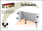
Software for photogrammetric self-calibration (v. 1.0)
(Laboratorio de Documentación Geométrica del Patrimonio (LDGP), 2002)
[EN] This software automatically serches the targets (white dots on a black surface) and
computes both 3D target coordinates and camera (internal and external) orientation.
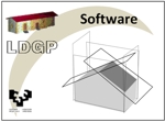
Software for photogrammetric modelling (v. 2.0)
(Laboratorio de Documentación Geométrica del Patrimonio (LDGP), 2003)
[EN] The scope of this software is to obtain 3D virtual models in VRML from a set of photographs (taken one by one) and points of known coordinates defining planes.
LDGP_Scan. Tools for the processing of point clouds
; Valle Melón, José Manuel (Laboratorio de Documentación Geométrica del Patrimonio (LDGP), 2007)
(Laboratorio de Documentación Geométrica del Patrimonio (LDGP), 2007)
[EN] A group of tools is presented that can work with files containing point clouds and generate some cartographic outputs.
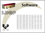
Software for the radiometric balance of photographic textures (v. 1.0)
; Valle Melón, José Manuel (Laboratorio de Documentación Geométrica del Patrimonio (LDGP), 2007)
(Laboratorio de Documentación Geométrica del Patrimonio (LDGP), 2007)
[EN] The software computes the statistics of a reference image and then balances the radiometry of a list of files to these values.