 Back
Back[A_Laguardia_Huesera] Documentación geométrica del dolmen de La Huesera (Laguardia, Álava). Campaña 2012.
| dc.contributor.author | Rodriguez-Miranda, Alvaro | |
| dc.contributor.author | Valle Melón, José Manuel  | |
| dc.coverage.spatial | Dolmen del Alto de la Huesera (Laguardia) | |
| dc.coverage.spatial | Laguardia, Álava, España/Spain (Getty TGN: 7007909) | |
| dc.coverage.temporal | 2012 | |
| dc.date.accessioned | 2018-05-14T13:32:44Z | |
| dc.date.available | 2018-05-14T13:32:44Z | |
| dc.date.issued | 2012-07 | |
| dc.identifier.citation | Laboratorio de Documentación Geométrica del Patrimonio (Universidad del País Vasco-Euskal Herriko Unibertsitatea UPV/EHU) –LDGP-. Documentación geométrica del dolmen de La Huesera (Laguardia, Álava). Campaña 2012. 2012 | es_ES |
| dc.identifier.uri | http://hdl.handle.net/10810/26809 | |
| dc.description | [ES] El presente informe corresponde a la segunda campaña de excavación de un total de cuatro que se documentaron en este monumento. Los informes del resto de campañas también están disponibles este repositorio: | es_ES |
| dc.description | ● LDGP_mem_019-1: "[A_Laguardia_Huesera] Documentación geométrica del dolmen de La Huesera (Laguardia, Álava)", http://hdl.handle.net/10810/9166 | es_ES |
| dc.description | ● LDGP_mem_019-3: "[A_Laguardia_Huesera] Documentación geométrica del dolmen de La Huesera (Laguardia, Álava). Campaña 2013.", http://hdl.handle.net/10810/26833 | es_ES |
| dc.description | ● LDGP_mem_019-4: "[A_Laguardia_Huesera] Documentación geométrica del dolmen de La Huesera (Laguardia, Álava). Campaña 2014.", http://hdl.handle.net/10810/26849 | es_ES |
| dc.description | [EN] This report is about the second (out of four) year of excavation. The reports of the rest of the years are also accessible in this repository: | en |
| dc.description | ● LDGP_mem_019-1: "Geometric documentation of the dolmen “Alto de la Huesera” (Laguardia, Álava, Spain)", http://hdl.handle.net/10810/9166 | en |
| dc.description | ● LDGP_mem_019-3: "Geometric documentation of the dolmen “Alto de la Huesera” (Laguardia, Álava, Spain). Year 2013.", http://hdl.handle.net/10810/26833 | en |
| dc.description | ● LDGP_mem_019-4: "Geometric documentation of the dolmen “Alto de la Huesera” (Laguardia, Álava, Spain). Year 2014.", http://hdl.handle.net/10810/26849 | en |
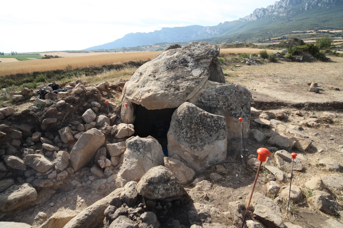
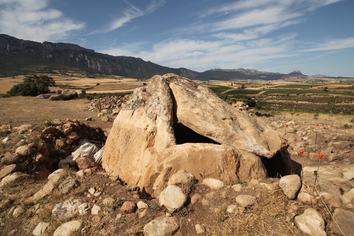
| dc.description.abstract | [ES] Tumba megalítica compuesta por 9 losas de gran tamaño, incluida la tapa. La estructura ocupa un espacio de 4 x 4 metros en planta, unos 3 metros de altura en la cámara. Conserva restos del túmulo que pudo llegar a tener unos 14 metros de radio. En la presente campaña se destapa parte del corredor. | es_ES |
| dc.description.abstract | El trabajo consiste en la obtención de una colección de fotografías para el modelado 3D y la generación de un vídeo de la excavación del corredor. Actualización del modelo vectorial mediante medidas con estación total. | es_ES |
| dc.description.abstract | [EN] Megalithic tomb composed of 9 slabs, including the cover. The structure takes up around 4 x 4 meters on surface and is 3 meters high in the chamber. Some remains of the burial mound (tumulus) survive up to 14 meters from the centre of the chamber. During this year’s excavations part of the corridor is discovered. | en |
| dc.description.abstract | The work consisted of taking a series of photographs for 3D modelling of the corridor and the generation of a video. The wireframe model was updated with measurements taken with a total station. | en |
| dc.description.sponsorship | Departamento de Cultura de la Exma. Diputación Foral de Álava | |
| dc.description.tableofcontents | [ES] Memoria del proyecto (25 páginas) en formato pdf + 3 fotografías de documentación (formato JPEG). | es_ES |
| dc.description.tableofcontents | [EN] General report (25 pages, in Spanish, PDF) + 3 photographs for documentation purposes (JPEG). | en |
| dc.language.iso | spa | es_ES |
| dc.publisher | Laboratorio de Documentación Geométrica del Patrimonio (UPV/EHU) | es_ES |
| dc.relation.ispartofseries | LDGP_mem_019-2 | |
| dc.relation.uri | http://hdl.handle.net/10810/9166 | |
| dc.relation.uri | http://hdl.handle.net/10810/26833 | |
| dc.relation.uri | http://hdl.handle.net/10810/26849 | |
| dc.rights | info:eu-repo/semantics/openAccess | es_ES |
| dc.rights.uri | http://creativecommons.org/licenses/by-nc/3.0/es/ | * |
| dc.subject | patrimonio cultural | es_ES |
| dc.subject | reconocimiento topográfico | es_ES |
| dc.subject | fotogrametría | es_ES |
| dc.subject | prehistoria | es_ES |
| dc.subject | arqueología | es_ES |
| dc.subject | cultural heritage | en |
| dc.subject | surveying | en |
| dc.subject | photogrammetry | en |
| dc.subject | prehistory | en |
| dc.subject | archaeology | en |
| dc.title | [A_Laguardia_Huesera] Documentación geométrica del dolmen de La Huesera (Laguardia, Álava). Campaña 2012. | es_ES |
| dc.title.alternative | Geometric documentation of the dolmen “Alto de la Huesera” (Laguardia, Álava, Spain). Year 2012. | en |
| dc.type | info:eu-repo/semantics/report | es_ES |
| dc.rights.holder | Atribución-NoComercial 3.0 España | * |
| dc.coverage.spatiallink | http://maps.google.com/maps?q=42.56954,-2.56609 | |
| dc.coverage.spatiallink | http://vocab.getty.edu/tgn/7007909 |
Files in this item

This item appears in the following Collection(s)

Except where otherwise noted, this item's license is described as Atribución-NoComercial 3.0 España