

 Back
Back[A_Laguardia_Huesera] Documentación geométrica del dolmen de La Huesera (Laguardia, Álava). Campaña 2014.
| dc.contributor.author | Pérez Vidiella, Pablo | |
| dc.contributor.author | Rodriguez-Miranda, Alvaro | |
| dc.contributor.author | Valle Melón, José Manuel  | |
| dc.coverage.spatial | Dolmen del Alto de la Huesera (Laguardia) | |
| dc.coverage.spatial | Laguardia, Álava, España/Spain (Getty TGN: 7007909) | |
| dc.coverage.temporal | 2014 | |
| dc.date.accessioned | 2018-05-14T14:46:12Z | |
| dc.date.available | 2018-05-14T14:46:12Z | |
| dc.date.issued | 2014-10 | |
| dc.identifier.citation | Laboratorio de Documentación Geométrica del Patrimonio (Universidad del País Vasco-Euskal Herriko Unibertsitatea UPV/EHU) –LDGP-. Documentación geométrica del dolmen de La Huesera (Laguardia, Álava). Campaña 2014. 2014 | es_ES |
| dc.identifier.uri | http://hdl.handle.net/10810/26849 | |
| dc.description | [ES] El presente informe corresponde a la cuarta campaña de excavación. Los informes del resto de campañas también están disponibles este repositorio: | es_ES |
| dc.description | ● LDGP_mem_019-1: "[A_Laguardia_Huesera] Documentación geométrica del dolmen de La Huesera (Laguardia, Álava)", http://hdl.handle.net/10810/9166 | es_ES |
| dc.description | ● LDGP_mem_019-2: "[A_Laguardia_Huesera] Documentación geométrica del dolmen de La Huesera (Laguardia, Álava). Campaña 2012.", http://hdl.handle.net/10810/26809 | es_ES |
| dc.description | ● LDGP_mem_019-3: "[A_Laguardia_Huesera] Documentación geométrica del dolmen de La Huesera (Laguardia, Álava). Campaña 2013.", http://hdl.handle.net/10810/26833 | es_ES |
| dc.description | [EN] This report is about the fourth (and last) year of excavation. The reports of the rest of the years are also accessible in this repository: | en |
| dc.description | ● LDGP_mem_019-1: "Geometric documentation of the dolmen “Alto de la Huesera” (Laguardia, Álava, Spain)", http://hdl.handle.net/10810/9166 | en |
| dc.description | ● LDGP_mem_019-2: "Geometric documentation of the dolmen “Alto de la Huesera” (Laguardia, Álava, Spain). Year 2012.", http://hdl.handle.net/10810/26809 | en |
| dc.description | ● LDGP_mem_019-3: "Geometric documentation of the dolmen “Alto de la Huesera” (Laguardia, Álava, Spain). Year 2013.", http://hdl.handle.net/10810/26833 | en |
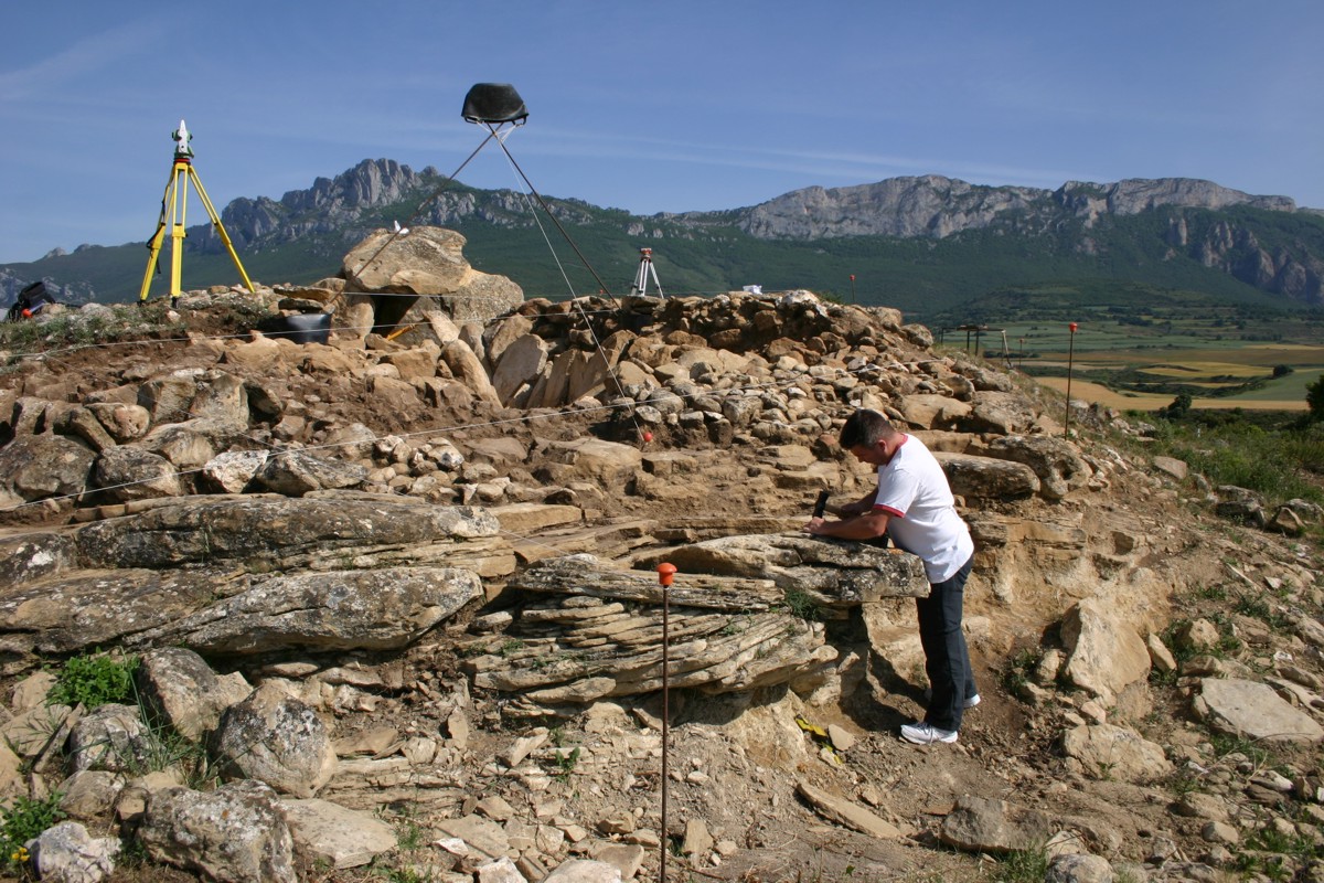
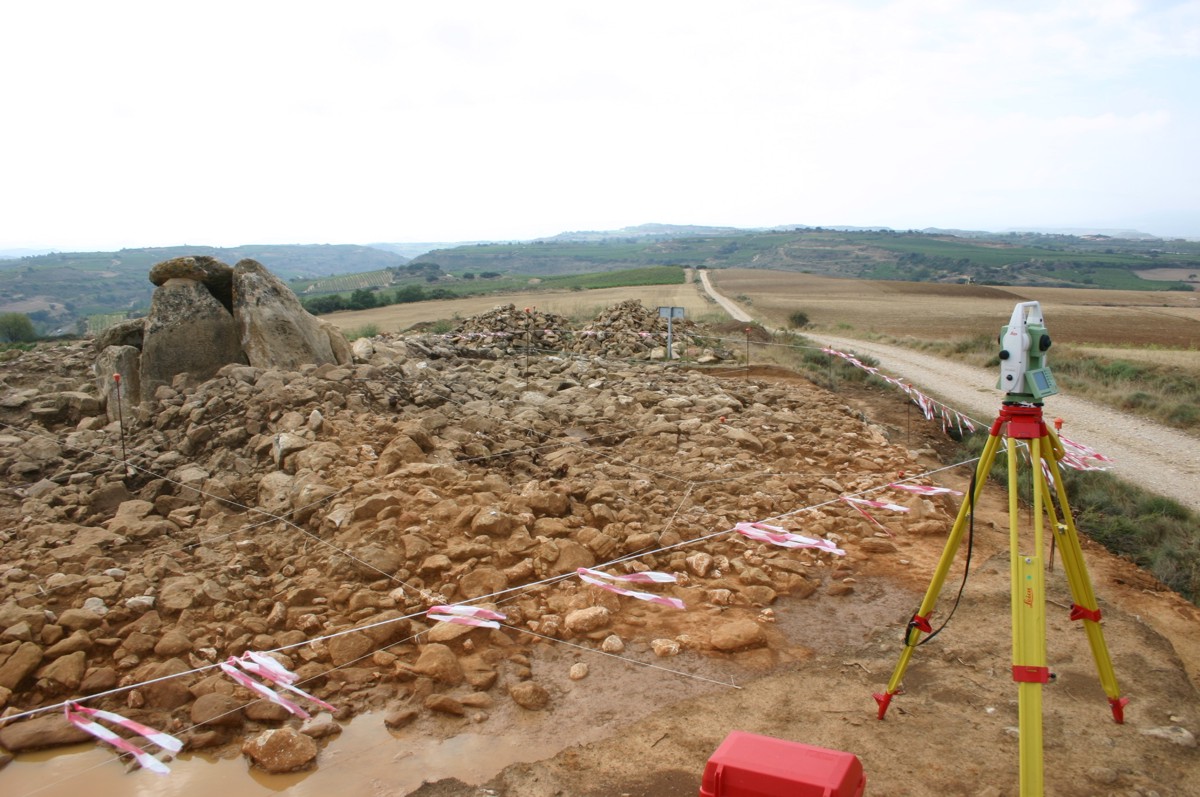
| dc.description.abstract | [ES] Tumba megalítica compuesta por 9 losas de gran tamaño, incluida la tapa. La estructura ocupa un espacio de 4 x 4 metros en planta, unos 3 metros de altura en la cámara. Conserva restos del túmulo que pudo llegar a tener unos 14 metros de radio. En la presente campaña continúa con la excavación del corredor y el túmulo. | es_ES |
| dc.description.abstract | Los trabajos de las presente campaña incluyen una colección de fotografías para el modelado 3D. Además se ha procedido a la actualización del modelo vectorial de superficies mediante fotogrametría convergente y medidas con estación total. | es_ES |
| dc.description.abstract | [EN] Megalithic tomb composed of 9 slabs, including the cover. The structure takes up around 4 x 4 meters on surface and is 3 meters high in the chamber. Some remains of the burial mound (tumulus) survive up to 14 meters from the centre of the chamber. During this year, the excavations in the corridor continued and the mound was discovered too. | es_ES |
| dc.description.abstract | The works consisted of photographs for 3D modelling of the current state of the corridor. The three-dimensional meshed model was updated with measurements taken with a total station and convergent photogrammetry. | es_ES |
| dc.description.sponsorship | Departamento de Cultura de la Exma. Diputación Foral de Álava | es_ES |
| dc.description.tableofcontents | [ES] Memoria del proyecto (45 páginas) en formato pdf + 4 fotografías de documentación (formato JPEG). | es_ES |
| dc.description.tableofcontents | [EN] General report (45 pages, in Spanish, PDF) + 4 photographs for documentation purposes (JPEG). | en |
| dc.language.iso | spa | es_ES |
| dc.publisher | Laboratorio de Documentación Geométrica del Patrimonio (UPV/EHU) | es_ES |
| dc.relation.ispartofseries | LDGP_mem_019-4 | |
| dc.relation.uri | http://hdl.handle.net/10810/9166 | |
| dc.relation.uri | http://hdl.handle.net/10810/26809 | |
| dc.relation.uri | http://hdl.handle.net/10810/26833 | |
| dc.rights | info:eu-repo/semantics/openAccess | es_ES |
| dc.rights.uri | http://creativecommons.org/licenses/by-nc/3.0/es/ | * |
| dc.subject | patrimonio cultural | es_ES |
| dc.subject | reconocimiento topográfico | es_ES |
| dc.subject | fotogrametría | es_ES |
| dc.subject | prehistoria | es_ES |
| dc.subject | arqueología | es_ES |
| dc.subject | cultural heritage | es_ES |
| dc.subject | surveying | es_ES |
| dc.subject | photogrammetry | es_ES |
| dc.subject | prehistory | es_ES |
| dc.subject | archaeology | es_ES |
| dc.title | [A_Laguardia_Huesera] Documentación geométrica del dolmen de La Huesera (Laguardia, Álava). Campaña 2014. | es_ES |
| dc.title.alternative | Geometric documentation of the dolmen “Alto de la Huesera” (Laguardia, Álava, Spain). Year 2014. | es_ES |
| dc.type | info:eu-repo/semantics/report | es_ES |
| dc.rights.holder | Atribución-NoComercial 3.0 España | * |
| dc.coverage.spatiallink | http://maps.google.com/maps?q=42.56954,-2.56609 | |
| dc.coverage.spatiallink | http://vocab.getty.edu/tgn/7007909 |
Files in this item
![No Thumbnail [100%x80]](data:image/svg+xml;base64,PD94bWwgdmVyc2lvbj0iMS4wIiBlbmNvZGluZz0iVVRGLTgiIHN0YW5kYWxvbmU9InllcyI/PjxzdmcgeG1sbnM9Imh0dHA6Ly93d3cudzMub3JnLzIwMDAvc3ZnIiB3aWR0aD0iMTI2NCIgaGVpZ2h0PSI4MCIgdmlld0JveD0iMCAwIDEyNjQgODAiIHByZXNlcnZlQXNwZWN0UmF0aW89Im5vbmUiPjwhLS0KU291cmNlIFVSTDogaG9sZGVyLmpzLzEwMCV4ODAvdGV4dDpObyBUaHVtYm5haWwKQ3JlYXRlZCB3aXRoIEhvbGRlci5qcyAyLjYuMC4KTGVhcm4gbW9yZSBhdCBodHRwOi8vaG9sZGVyanMuY29tCihjKSAyMDEyLTIwMTUgSXZhbiBNYWxvcGluc2t5IC0gaHR0cDovL2ltc2t5LmNvCi0tPjxkZWZzPjxzdHlsZSB0eXBlPSJ0ZXh0L2NzcyI+PCFbQ0RBVEFbI2hvbGRlcl8xOTYxYmMzZGUwYyB0ZXh0IHsgZmlsbDojQUFBQUFBO2ZvbnQtd2VpZ2h0OmJvbGQ7Zm9udC1mYW1pbHk6QXJpYWwsIEhlbHZldGljYSwgT3BlbiBTYW5zLCBzYW5zLXNlcmlmLCBtb25vc3BhY2U7Zm9udC1zaXplOjYzcHQgfSBdXT48L3N0eWxlPjwvZGVmcz48ZyBpZD0iaG9sZGVyXzE5NjFiYzNkZTBjIj48cmVjdCB3aWR0aD0iMTI2NCIgaGVpZ2h0PSI4MCIgZmlsbD0iI0VFRUVFRSIvPjxnPjx0ZXh0IHg9IjM0MC41IiB5PSI2OS40Ij5ObyBUaHVtYm5haWw8L3RleHQ+PC9nPjwvZz48L3N2Zz4=)


![No Thumbnail [100%x80]](data:image/svg+xml;base64,PD94bWwgdmVyc2lvbj0iMS4wIiBlbmNvZGluZz0iVVRGLTgiIHN0YW5kYWxvbmU9InllcyI/PjxzdmcgeG1sbnM9Imh0dHA6Ly93d3cudzMub3JnLzIwMDAvc3ZnIiB3aWR0aD0iMTI2NCIgaGVpZ2h0PSI4MCIgdmlld0JveD0iMCAwIDEyNjQgODAiIHByZXNlcnZlQXNwZWN0UmF0aW89Im5vbmUiPjwhLS0KU291cmNlIFVSTDogaG9sZGVyLmpzLzEwMCV4ODAvdGV4dDpObyBUaHVtYm5haWwKQ3JlYXRlZCB3aXRoIEhvbGRlci5qcyAyLjYuMC4KTGVhcm4gbW9yZSBhdCBodHRwOi8vaG9sZGVyanMuY29tCihjKSAyMDEyLTIwMTUgSXZhbiBNYWxvcGluc2t5IC0gaHR0cDovL2ltc2t5LmNvCi0tPjxkZWZzPjxzdHlsZSB0eXBlPSJ0ZXh0L2NzcyI+PCFbQ0RBVEFbI2hvbGRlcl8xOTYxYmM0NTQwOCB0ZXh0IHsgZmlsbDojQUFBQUFBO2ZvbnQtd2VpZ2h0OmJvbGQ7Zm9udC1mYW1pbHk6QXJpYWwsIEhlbHZldGljYSwgT3BlbiBTYW5zLCBzYW5zLXNlcmlmLCBtb25vc3BhY2U7Zm9udC1zaXplOjYzcHQgfSBdXT48L3N0eWxlPjwvZGVmcz48ZyBpZD0iaG9sZGVyXzE5NjFiYzQ1NDA4Ij48cmVjdCB3aWR0aD0iMTI2NCIgaGVpZ2h0PSI4MCIgZmlsbD0iI0VFRUVFRSIvPjxnPjx0ZXh0IHg9IjM0MC41IiB5PSI2OS40Ij5ObyBUaHVtYm5haWw8L3RleHQ+PC9nPjwvZz48L3N2Zz4=)
This item appears in the following Collection(s)

Except where otherwise noted, this item's license is described as Atribución-NoComercial 3.0 España