 Back
Back[A_Llodio_Yermo] Documentación geométrica para la puesta en valor y difusión social del Santuario de Santa María del Yermo (Laudio/Llodio, Álava). Campaña 2017
| dc.contributor.author | Rodriguez-Miranda, Alvaro | |
| dc.contributor.author | Valle Melón, José Manuel  | |
| dc.coverage.spatial | Santuario del Yermo (Laudio/Llodio) | es_ES |
| dc.coverage.spatial | Laudio/Llodio, Álava, España/Spain (Getty TGN: 7307306) | es_ES |
| dc.date.accessioned | 2019-03-22T12:13:47Z | |
| dc.date.available | 2019-03-22T12:13:47Z | |
| dc.date.issued | 2017-12 | |
| dc.identifier.citation | Laboratorio de Documentación Geométrica del Patrimonio (Universidad del País Vasco-Euskal Herriko Unibertsitatea UPV/EHU) –LDGP-. Documentación geométrica para la puesta en valor y difusión social del Santuario de Santa María del Yermo (Laudio/Llodio, Álava). Campaña 2017. 2017. | es_ES |
| dc.identifier.uri | http://hdl.handle.net/10810/32114 | |
| dc.description | [ES] El presente informe corresponde a la tercera campaña de excavación. Las amteriores campañas también están disponibles en este repositorio: | es_ES |
| dc.description | ● LDGP_mem_040-1: "[A_Llodio_Yermo] Documentación geométrica para la puesta en valor y difusión social del Santuario de Santa María del Yermo (Laudio/Llodio, Álava)", http://hdl.handle.net/10810/17466 | es_ES |
| dc.description | ● LDGP_mem_040-2: "[A_Llodio_Yermo] Documentación geométrica para la puesta en valor y difusión social del Santuario de Santa María del Yermo (Laudio/Llodio, Álava). Campaña 2016.", http://hdl.handle.net/10810/24487/17466 | |
| dc.description | [EN] This report is about the third year of works in the site. The previous years are also available in this repository: | en |
| dc.description | ● LDGP_mem_040-1: "Geometric documentation for valuing and extending the social use of “El Yermo” Sanctuary (Llaudio/Llodio, Álava, Spain)", http://hdl.handle.net/10810/17466 | |
| dc.description | ● LDGP_mem_040-2: "Geometric documentation for valuing and extending the social use of “El Yermo” Sanctuary (Llaudio/Llodio, Álava, Spain). Year 2016.", http://hdl.handle.net/10810/24487/17466 | |
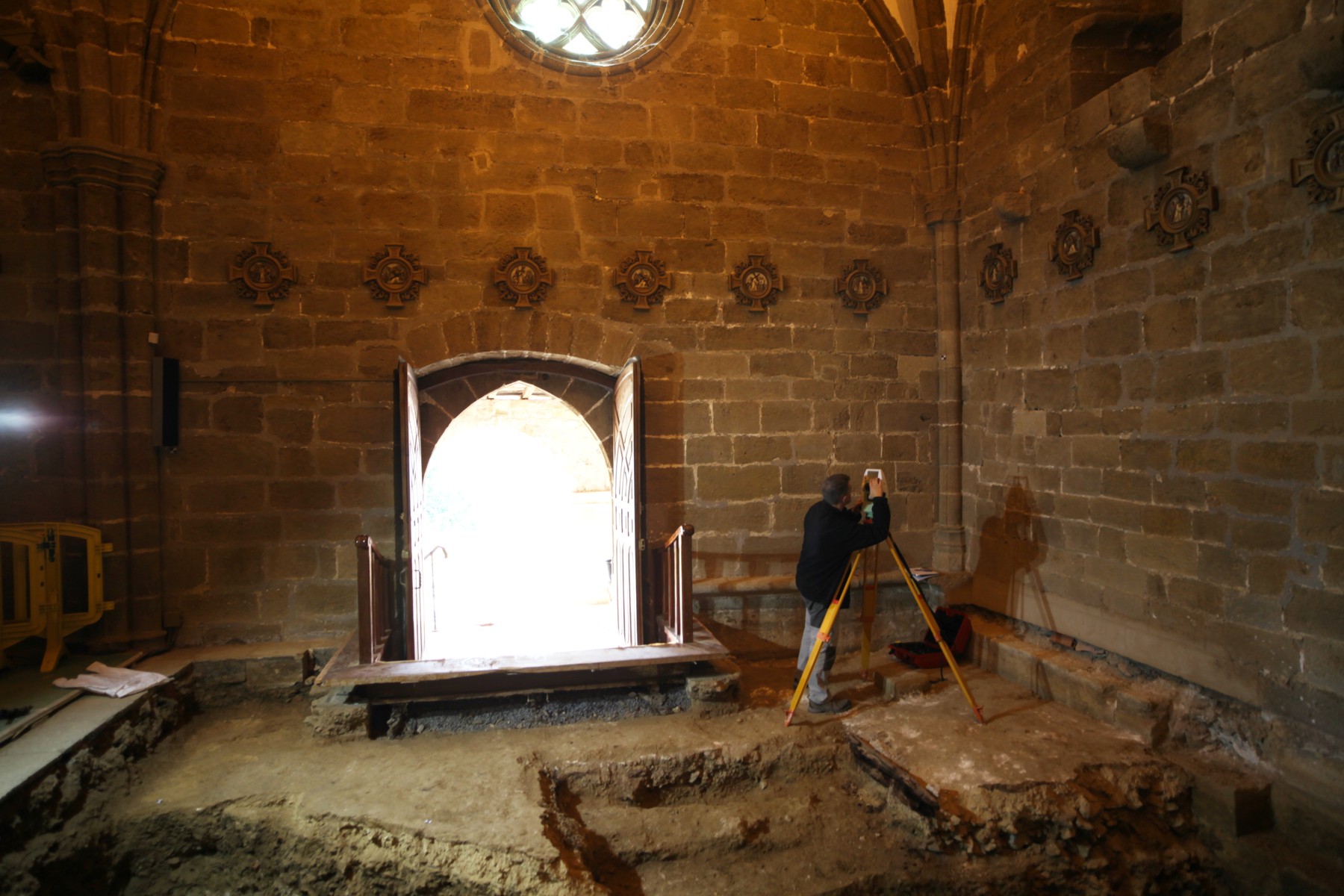
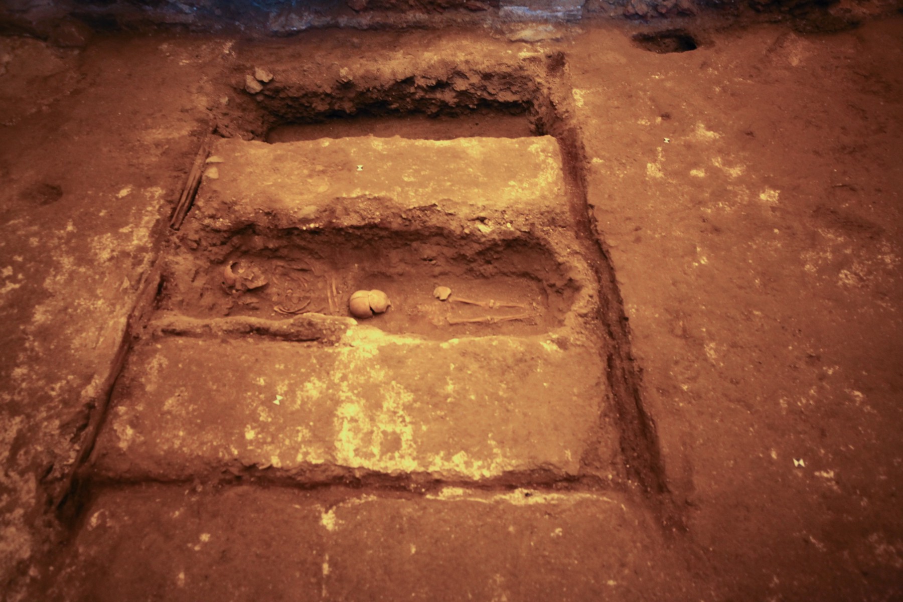
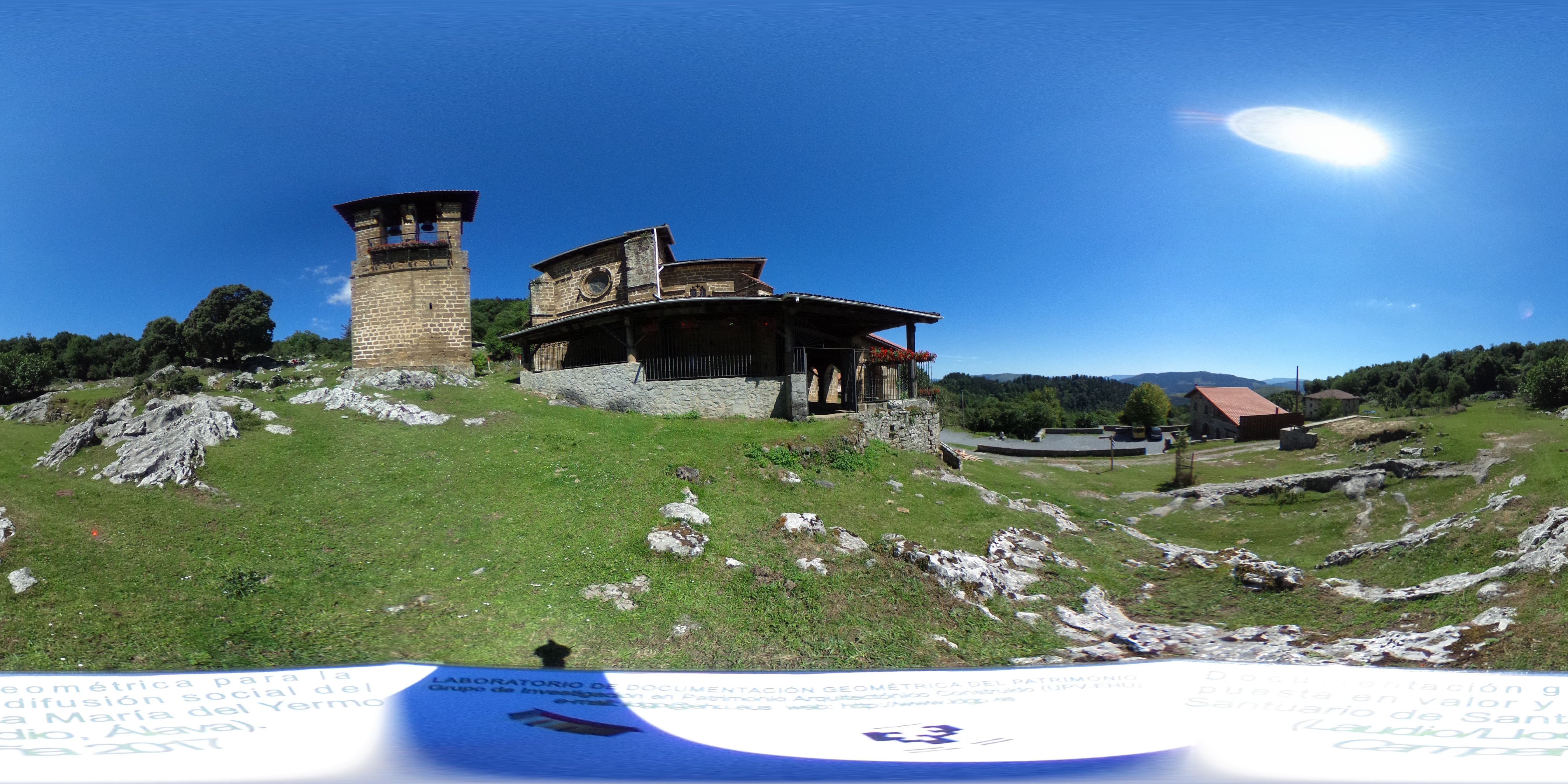
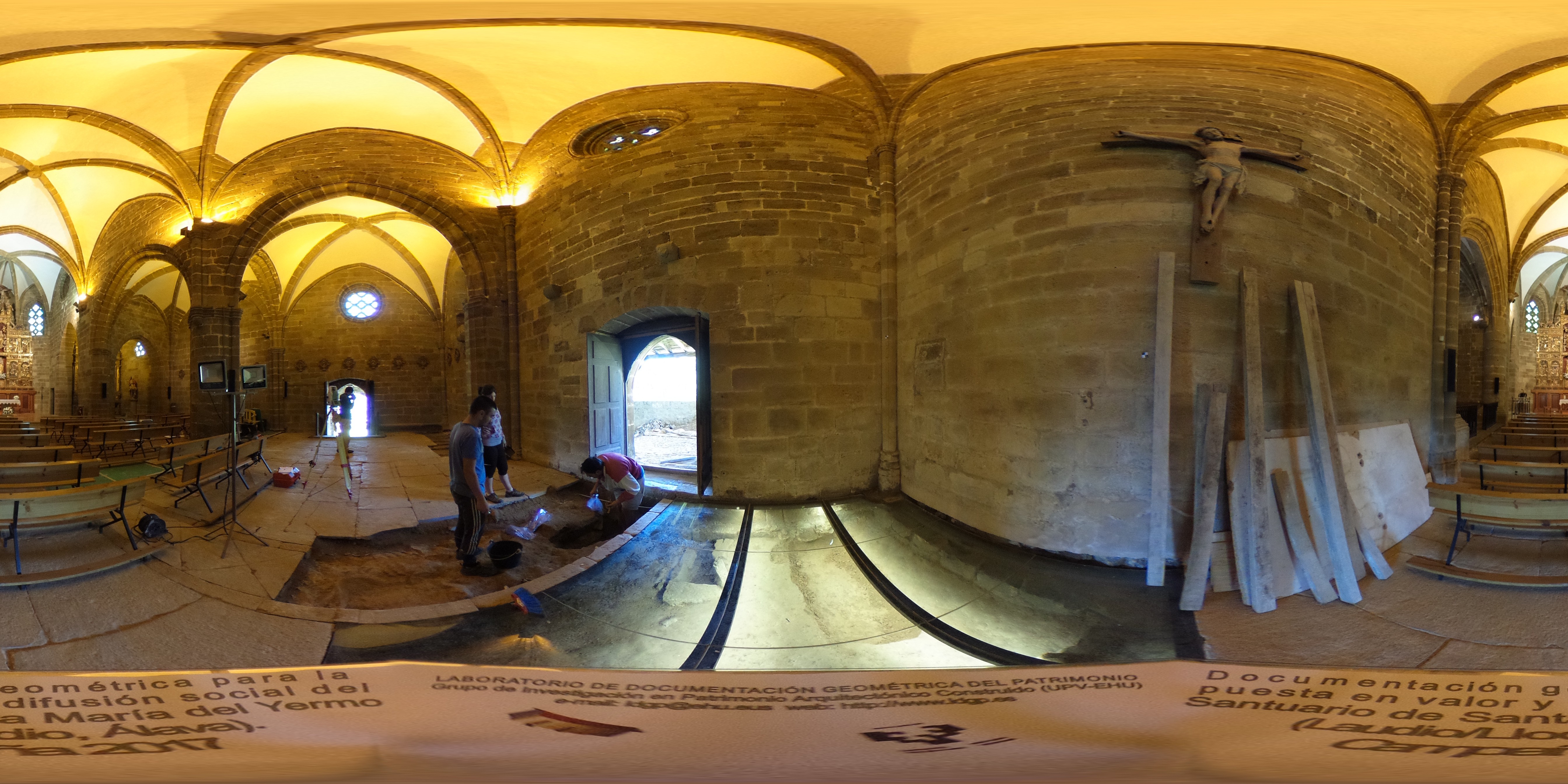
| dc.description.abstract | [ES] La iglesia de Santa María tiene una planta de unos 22x18 metros y cuenta con tres pórticos (sur, oeste y norte) así como una espadaña exenta. Adyacente al sudeste se encuentra la ermita de Santa Lucía. La excavación de esta campaña se centró en el final del intercolumnio de la nave sur junto a la puerta de acceso, de unos 6 x 3 metros que extienden las excavaciones realizadas en la campaña anterior | es_ES |
| dc.description.abstract | La documentación de las excavaciones se ha realizado mediante topografía clásica para la identificación de los perímetros de las unidades estratigráficas y fotogrametría para la generación de modelos 3D con textura fotográfica de cada nivel de excavación. | es_ES |
| dc.description.abstract | [EN] The church of Santa María has a plan of around 22 by 18 metres and counts on three porticos (north, west and south) and a free-standing bell gable. Adjacent to this building on the southeast side is Santa Lucía’s shrine. The excavation of this campaign focused on the end of the intercolumn of the south aisle next to the access door, it has about 6 x 3 meters that extend the excavations carried out in the previous season. | es_ES |
| dc.description.abstract | The documentation of the excavation was done with conventional surveying equipment (total station) for the line drawing of the unities and photogrammetry in order to obtain a 3D model with photographic texture of each level. | es_ES |
| dc.description.sponsorship | Gobierno Vasco, Ayuntamiento de Laudio/Llodio | es_ES |
| dc.description.tableofcontents | [ES] Memoria del proyecto (50 páginas incluyendo anexos, en español, formato PDF) + 3 fotografías de documentación + 3 imágenes panorámicas. | es_ES |
| dc.description.tableofcontents | [EN] Report with annexes (49 pages in Spanish, PDF file) + 3 photograph for documentation purposes and 3 panoramic images. | en |
| dc.language.iso | spa | es_ES |
| dc.relation.ispartofseries | LDGP_mem_040-3 | |
| dc.relation.uri | http://hdl.handle.net/10810/24487 | |
| dc.relation.uri | http://hdl.handle.net/10810/17466 | |
| dc.rights | info:eu-repo/semantics/openAccess | es_ES |
| dc.rights.uri | http://creativecommons.org/licenses/by-nc-nd/3.0/es/ | * |
| dc.subject | patrimonio cultural | es_ES |
| dc.subject | edificio religioso | es_ES |
| dc.subject | reconocimiento topográfico | es_ES |
| dc.subject | fotogrametría | es_ES |
| dc.subject | cultural heritage | es_ES |
| dc.subject | religious buildings | es_ES |
| dc.subject | surveying | es_ES |
| dc.subject | photogrammetry | es_ES |
| dc.title | [A_Llodio_Yermo] Documentación geométrica para la puesta en valor y difusión social del Santuario de Santa María del Yermo (Laudio/Llodio, Álava). Campaña 2017 | es_ES |
| dc.title.alternative | Geometric documentation for valuing and extending the social use of “El Yermo” Sanctuary (Llaudio/Llodio, Álava, Spain). Year 2017. | es_ES |
| dc.type | info:eu-repo/semantics/report | es_ES |
| dc.rights.holder | Atribución-NoComercial-SinDerivadas 3.0 España | * |
| dc.coverage.spatiallink | http://maps.google.com/maps?q=43.17187,-2.97168 | |
| dc.coverage.spatiallink | http://vocab.getty.edu/tgn/7307306 | |
| dc.contributor.funder | Gobierno Vasco, Ayuntamiento de Laudio/Llodio |
Files in this item


This item appears in the following Collection(s)

Except where otherwise noted, this item's license is described as Atribución-NoComercial-SinDerivadas 3.0 España